3D Visualization software like Lumion and gathering data from OpenStreetMap or similar terrain mapping is all good for a basic 3D context model, but it is nowhere near good enough for displaying your model in real location in all its glory. That’s where drones may come in handy.
Most 3D terrain data from OS or similar sources come in flat colorless detail-less blocks only, and satellite imagery are way too low-res to have any effect. At least, those that you can access publicly. These options are great for quickly mapping out the urban or rural environments around your model, but drastically limits options and capabilities when preparing client presentation renders.
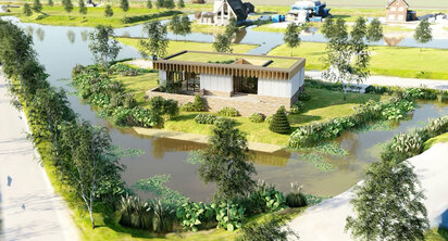
This is where drones may be very useful. You can get into really speedy context-building without having to sacrifice photorealism. The idea is based upon taking lots of photos of the area with a drone with a high-res camera, and then using those photos to match and render the 3D context in SketchUp.
Incidentally, drones are already used in construction in a similar manner. They fly them around the site, especially in case of large or tall projects, to see the progress and to inspect difficult-to-reach spots. Now we can, and should, use a similar idea in SketchUp 3D context modeling.
Of course, to use this tactic in architecture design and visualization, you need some help. A testing team of Lumion used a modern drone and a drone-to-3D capture software and designed a workflow that would be easy for most architects. Not only that, it will be time-saving too – all the capture and fitting work for a standard-sized project (let’s say, 300 by 300 meters) can be finished in a day.
The team used the drone device named DJI Mavic Air. It is less than a kilogram in weight and can speedily fly for 20 minutes (or, 10 kilometers) on full charge. While doing that, it can stream 4k videos and 12k photos! It cost them only $800, so, seeing the return, it is cost-efficient as well. Combined with a standard 10-inch tablet (with enough storage), this drone can be a great modern surveyor.
But taking random pictures darting around the site is not only clueless, it is also inefficient. You need to plan carefully about where the drone should pause, look in what direction, and take the picture. Pre-planning that much, and flying the drone with that kind of precision isn’t normal for us standard architects, yeah? Yes, the testing team thought that after just one try, and they opted for Drone Harmony.
Most 3D terrain data from OS or similar sources come in flat colorless detail-less blocks only, and satellite imagery are way too low-res to have any effect. At least, those that you can access publicly. These options are great for quickly mapping out the urban or rural environments around your model, but drastically limits options and capabilities when preparing client presentation renders.
This is where drones may be very useful. You can get into really speedy context-building without having to sacrifice photorealism. The idea is based upon taking lots of photos of the area with a drone with a high-res camera, and then using those photos to match and render the 3D context in SketchUp.
Incidentally, drones are already used in construction in a similar manner. They fly them around the site, especially in case of large or tall projects, to see the progress and to inspect difficult-to-reach spots. Now we can, and should, use a similar idea in SketchUp 3D context modeling.
Of course, to use this tactic in architecture design and visualization, you need some help. A testing team of Lumion used a modern drone and a drone-to-3D capture software and designed a workflow that would be easy for most architects. Not only that, it will be time-saving too – all the capture and fitting work for a standard-sized project (let’s say, 300 by 300 meters) can be finished in a day.
The team used the drone device named DJI Mavic Air. It is less than a kilogram in weight and can speedily fly for 20 minutes (or, 10 kilometers) on full charge. While doing that, it can stream 4k videos and 12k photos! It cost them only $800, so, seeing the return, it is cost-efficient as well. Combined with a standard 10-inch tablet (with enough storage), this drone can be a great modern surveyor.
But taking random pictures darting around the site is not only clueless, it is also inefficient. You need to plan carefully about where the drone should pause, look in what direction, and take the picture. Pre-planning that much, and flying the drone with that kind of precision isn’t normal for us standard architects, yeah? Yes, the testing team thought that after just one try, and they opted for Drone Harmony.
~~~~~~~~~~~~~~~~~~~~~~~~~~~~
Published By
Arka Roy
www.sketchup4architect.com
~~~~~~~~~~~~~~~~~~~~~~~~~~~~
Published By
Arka Roy
www.sketchup4architect.com
~~~~~~~~~~~~~~~~~~~~~~~~~~~~
 RSS Feed
